
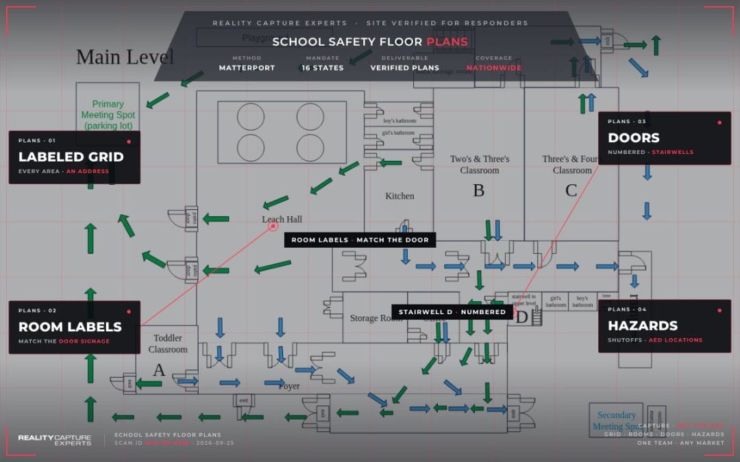
School safety floor plans give responders a site verified map of a campus they have never entered. State mapping laws ask for on site verified plans with a labeled grid, numbered exterior doors and stairwells, room labels that match the signage, and hazard and AED locations.
The requirement is not a drawing. It is a map a stranger can act on under pressure, in a format the software responders already use can open. That distinction is what most existing district plans fail on.
Key Takeaways
- As of 2026, 16 states require or fund school safety mapping. Five mandate it and eleven fund it through grants.
- Responders need site verified plans with a grid, numbered doors, room labels that match the signage, and hazard and AED locations.
- Construction drawings rarely meet that standard because of renumbering, missed renovations, and the absence of a hazard layer.
- Capture does the site verification once, a mapping provider produces the gridded deliverable, and the map is recaptured at renovation close out.
Which states require school safety mapping?
As of 2026, 16 states have passed legislation requiring or funding school safety mapping. Five mandate it and eleven fund it through grant programs. Wisconsin, Delaware, Florida, Illinois, Michigan, New Jersey, Texas, Kentucky, Nebraska, Maryland, and Virginia have all moved bipartisan critical incident mapping laws or state level initiatives. New Hampshire is the most recent large commitment: on June 3, 2026 the state approved 2.6 million dollars to deliver critical incident mapping for every public school.
Check your own state’s statute and grant window before scoping anything, because the funding mechanism often sets the deadline. A grant funded program usually has a shorter runway than a mandate.
What has to be on the map?
The core elements repeat across states, because they come from what responders need rather than from local policy. The map starts with accurate floor plans overlaid on current aerial imagery, so the interior and the site line up, and an alphanumeric grid that gives every part of the campus an address responders can call out. Room labels have to match the numbers actually posted on the doors, and exterior doors and stairwells are numbered. Hazard locations, utility shutoffs, and AED positions go on the map, along with site features such as parking, fields, and access roads.
Two rules sit behind all of it. The plan has to be site verified, meaning somebody walked the building and confirmed it. And it has to be delivered in a format responder software can open, not a PDF in a binder in the front office.
Why do existing district plans usually fail the requirement?
Most districts are working from construction drawings, and construction drawings answer a different question. They show what was built, at the time it was built, using room numbers the architect assigned. Three mismatches show up almost every time. The room numbers on the drawing do not match the numbers on the doors, because the district renumbered at some point. Additions and renovations are missing, so a corridor on the map dead ends at a wall that was removed. And there is no grid, no door numbering, and no hazard layer, because none of that was ever the drawing’s job.
A district that hands a responder agency its as-built set has not met a mapping requirement. It has handed over a starting point.
How does a 3D capture feed the map?
Capture handles the site verification step, which is the expensive part of the requirement. Walking every building to confirm layout, door numbering, signage, and hazard locations is the work, and a capture does that walk once and records it. From one capture you get a measurable floor plan that matches current conditions, visual confirmation of the numbers posted on doors and stairwells, documented locations of shutoffs, panels, and AEDs, and a record the mapping vendor or agency can check against without returning to site.
The capture is not the map. A mapping provider or the responder agency still produces the gridded deliverable in their required format. What the capture removes is the repeat site visit every time a room label is questioned or a building changes. Responders benefit once the work is done. In Aberdeen, South Dakota, Digital Twin Imaging captured every kindergarten through 12th grade room, and in timed SWAT training simulations officers using the Matterport models cut room to room search times from over seven minutes to under thirty seconds, according to Matterport’s public safety case study. Running that verification across every building to one standard is the same program described in how to document facility conditions across an entire school district.
Who keeps the map current?
The district, and it needs to be written into somebody’s job rather than left to good intentions. A map that is two renovations out of date is worse than no map, because responders will trust it. The practical rule is the same one that keeps facility records current. Any building that gets a renovation, an addition, or a renumbering gets recaptured and remapped at project close out, written into the project specification so it is funded rather than requested. Anything that changes a door number, a corridor, or a shutoff location triggers it.
What Happens Next
If your state has a mandate or an open grant window, the first step is confirming what format your responder agency needs, then capturing the buildings that gate the deadline. RCE sequences the buildings, deploys technicians against one written scope, applies specialist quality control with post production notes to every scan, and delivers verified floor plans your mapping provider can build on. One point of contact handles scheduling, coordination, and delivery across every site. Reach the team at 833-723-8326 or info@realitycaptureexperts.com.
Related reading: how to document facility conditions across an entire school district and when you can 3D scan a school building.
External references: Facility Executive on critical incident mapping laws and New Hampshire statewide mapping program.
Frequently Asked Questions
Does a Matterport tour satisfy a mapping mandate on its own?
No. Mandates ask for gridded, labeled plans in a format responder software can open. The capture provides the site verified basis for those plans and the visual record behind them.
Who has access to the data?
The district decides and should document it before capture. Responder agencies, district safety staff, and design teams typically get different levels. Deliverables are set up in the district’s name so access does not depend on a vendor account.
Is grant funding available?
In eleven of the sixteen states with legislation, mapping is funded through grants rather than mandated. Check your state education department’s current program, because windows open and close on their own schedule.
How often should the map be updated?
At close out of any project that changes layout, door numbering, or utility shutoff locations, plus a periodic review so no building’s record sits unverified for years. Write it into project specifications rather than tracking it separately.