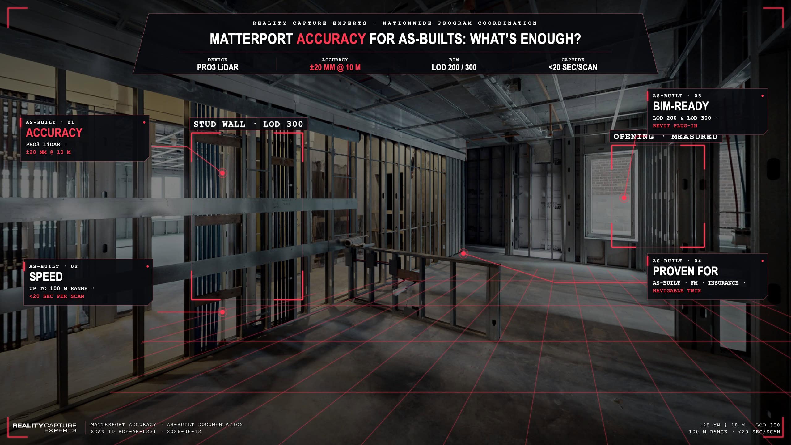
Matterport accuracy of the Pro3 captures at ±20 mm (±0.8 in) at 10 m (33 ft). That accuracy is sufficient for LOD 200 BIM, LOD 300 architectural work, real estate documentation, and most facility management uses. For survey-grade structural monitoring or sub-centimeter MEP fabrication, survey-grade LiDAR is still the right tool.
This post unpacks where Matterport fits in the as-built toolkit, where it does not, and how to scope projects so you do not overpay for accuracy you cannot use — or under-spec accuracy you need.
What Are Matterport Pro3’s Actual Specifications?
Matterport Pro3 uses a LiDAR sensor with a capture range up to 100 m (about 330 ft) and accuracy of ±20 mm (±0.8 in) at 10 m (33 ft). Capture time per scan position is under 20 seconds. The camera operates indoors and outdoors, including in direct sunlight.
That is a meaningful jump from Pro2, which ran ±44–58 mm (±1.7–2.3 in) at 4.5 m (15 ft). The Pro3 sensor is what moved Matterport from “real estate visualization tool” into legitimate AEC documentation territory.
Where Is Matterport Accuracy Sufficient?
Matterport Pro3 accuracy is sufficient for:
- Real estate and facility documentation, where the deliverable is a navigable digital twin for due diligence, leasing, marketing, or remote walkthroughs.
- LOD 200 BIM, where elements are defined by approximate quantity, size, shape, and location.
- LOD 300 architectural BIM in most renovation and retrofit scope — walls, doors, windows, slabs.
- Quantity takeoffs and area measurements, where ±20 mm (±0.8 in) at 10 m (33 ft) is well below tolerance.
- Pre-loss and post-loss insurance documentation, where the value is in the time-stamped, measurable record of the space.
- Facility management baseline scans for capital planning and space optimization.
For these use cases, Matterport is the right tool because of speed: 20 seconds per scan position, 100 m (330 ft) range, full coverage of a typical office floor in a single field day. Survey-grade LiDAR would deliver tighter tolerance at multiple times the field time and cost.
Where Does Matterport Hit Its Limits?
Matterport hits its limits when the project tolerance is below 10 mm (0.4 in) or when the use case requires sub-centimeter accuracy at distance. Specifically:
- Survey-grade structural monitoring (e.g., bridge deflection, settlement studies).
- Sub-centimeter MEP fabrication — prefab pipe runs, structural steel connections at LOD 400.
- Forensic engineering where the legal standard requires survey-grade documentation.
- Heritage conservation where sub-millimeter detail of ornamental surfaces is the deliverable.
For these uses, survey-grade LiDAR (Leica RTC360, FARO Focus, etc.) is still the standard. Matterport is not a replacement — it is a complement.
How Do You Decide Between Matterport and Survey-Grade LiDAR?
The decision comes down to project tolerance and downstream use. Two questions to ask:
What is the tightest tolerance any downstream user will measure against this dataset? If the answer is 10 mm (0.4 in) or tighter, scope survey-grade LiDAR for that work and Matterport for navigation and the rest of the building. If the answer is wider than 10 mm (0.4 in), Matterport Pro3 is likely sufficient and significantly faster.
What is the deliverable for? If the deliverable feeds LOD 200 or LOD 300 architectural BIM, real estate documentation, facility management, or insurance, Matterport is the right tool. If the deliverable feeds LOD 350+ MEP fabrication, structural monitoring, or forensic litigation, survey-grade LiDAR enters the scope.
On many projects, the answer is both — Matterport for the navigable twin and the bulk of the building, survey-grade LiDAR for the specific zones where tolerance demands it. A coordinated capture program scopes both tools onto the same site without duplicating field time.
How Does Matterport Compare to Photogrammetry?
Matterport Pro3 is not photogrammetry — it uses LiDAR. The accuracy gap between LiDAR and photogrammetry is real: LiDAR-based capture delivers 1–5 mm (0.04–0.2 in) raw accuracy in survey-grade implementations, while photogrammetry typically achieves 5–15 mm (0.2–0.6 in) under good conditions and 3–5 cm (1.2–2 in) under typical interior lighting.
The practical implication: Matterport is closer in performance to a survey-grade LiDAR scanner than to a photogrammetric reconstruction. The difference between Matterport Pro3 and a Leica RTC360 is one of degree (±20 mm / ±0.8 in vs. sub-cm), not category.
What Does Matterport Capture That Survey-Grade LiDAR Does Not?
Matterport produces a navigable digital twin alongside the point cloud — and that twin is the deliverable downstream users actually open. A facility manager, a leasing broker, an insurance adjuster, a remote design team — none of them open a raw point cloud. They open the twin.
A survey-grade scan generates a point cloud and registered imagery, but the user experience is built downstream — Cyclone, ReCap, navigation software. Matterport bundles the twin natively, which is why it has become the de facto tool for as-built documentation that needs to be usable by people who are not point cloud specialists.
On a coordinated capture project, that pairing matters: the BIM team uses the point cloud, the rest of the project uses the twin.
How RCE Scopes Accuracy on Mixed Projects
RCE scopes accuracy per zone, or per customer requirements, not per project. The kickoff conversation maps the building into zones by tolerance requirement: where does Matterport land, and are any survey-grade LiDAR scans needed.
That mapping drives field scope, hardware deployment, and modeling workflow. A typical office or retail project runs entirely on Matterport Pro3. A complex MEP retrofit or a hospital mechanical penthouse runs Matterport for navigation and survey-grade LiDAR in the dense zones. RCE coordinates both on a single field mobilization.
What Happens Next
A 15-minute scoping call usually settles the accuracy question. Once project tolerance and downstream use are mapped, the right tool for each zone falls out.
FAQ
Is Matterport accurate enough for Revit?
For LOD 200 and LOD 300 architectural work, yes. Matterport’s BIM file output and direct Revit plug-in import is built for that workflow.
What is the practical accuracy of Matterport Pro3 in a typical office?
±20 mm (±0.8 in) at 10 m (33 ft). In a typical office where the longest interior span is 8–15 m (26–49 ft), that holds the model well inside LOD 300 tolerance.
Can Matterport be used for legal or forensic documentation?
Yes, for pre-loss and post-loss property documentation, claims comparison, and time-stamped condition records. For sub-centimeter forensic engineering or accident reconstruction, survey-grade LiDAR is typically required.
Do I need both Matterport and LiDAR?
On most projects, no — Matterport Pro3 alone is sufficient. On complex MEP, structural monitoring, or sub-cm work, scoping both onto the same field mobilization is the most cost-effective approach.